Showing 50 items matching metropolitan ring road
-
 Eltham District Historical Society Inc
News Clipping, Advertisement: Changes to traffic conditions on Metropolitan Ring Road and Greensborough Bypass; Vic Roads, Diamond Valley Leader, 3 August 2005, p25, 2005
... Metropolitan Ring Road and Greensborough Bypass; Vic Roads, Diamond...Greensborough Bypass, Metropolitan Ring Road, Road... on Metropolitan Ring Road and Greensborough Bypass; Vic Roads, Diamond ...Newsprint greensborough bypass, metropolitan ring road, road construction -
 Greensborough Historical Society
Newspaper Clipping, Diamond Valley Leader, Pressure for road link builds, 24/02/2016
... metropolitan ring road... Ring Road and Eastern Freeway should be a priority.... that the missing link between the Metropolitan Ring Road and Eastern ...RACV reports that the missing link between the Metropolitan Ring Road and Eastern Freeway should be a priority.News clipping, black text.eastern freeway, east west link project, metropolitan ring road -
 Greensborough Historical Society
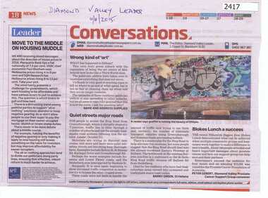
Newspaper Clipping, Conversations - Greensborough Ring Road, 11/11/2015
... metropolitan ring road... graffiti in Eltham and traffic around the Metropolitan Ring Road.... and traffic around the Metropolitan Ring Road. metropolitan ring road ...Letters to the editor of Diamond Valley Leader covering graffiti in Eltham and traffic around the Metropolitan Ring Road.News clipping, black text, colour image.metropolitan ring road, graffiti -
 Greensborough Historical Society
Newspaper Clipping, Diamond Valley Leader, Link road depends on poll, 14/12/2016
... metropolitan ring road...The North East Link will connect the Metropolitan Ring Road... will connect the Metropolitan Ring Road and Eastern Freeway ...The North East Link will connect the Metropolitan Ring Road and Eastern Freeway. It is under consideration by the Victorian Government.News clipping, black text. north east link, metropolitan ring road -
 Greensborough Historical Society
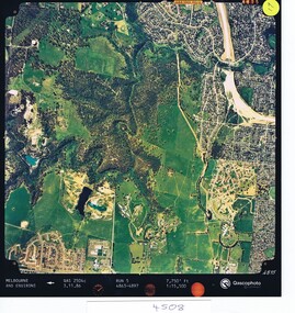
Aerial photograph, Qascophoto, Greensborough, 03/11/1986
... metropolitan ring road... Greensborough by-pass construction and Metropolitan Ring Road... Greensborough by-pass construction and Metropolitan Ring Road ...Aerial survey of Plenty Gorge Park area, including Greensborough by-pass construction and Metropolitan Ring Road reservation.An historical view of developing GreensboroughColour aerial photograph QAS 2504c run 5 3/11/86 1:15,500 by Qascophotoplenty gorge park, greensborough bypass, metropolitan ring road -
 Greensborough Historical Society
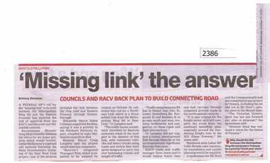
Newspaper Clipping, "Missing Link" the answer, 21/10/2015
... metropolitan ring road... Link Project between the Metropolitan Ring Road and Eastern... the Metropolitan Ring Road and Eastern Freeway. east west link project ...Both Banyule and Nillumbik Councils support the East West Link Project between the Metropolitan Ring Road and Eastern Freeway.News clipping, black text.east west link project, metropolitan ring road, nillumbik council, banyule city council -
 Greensborough Historical Society
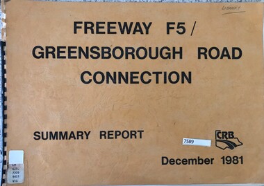
Book - Report, Country Roads Board, Freeway F5 / Greensborough Road connection. December 1981, Summary Report, 1981_
... metropolitan ring road... for the F5 Freeway (now Metropolitan Ring Road) between Dalton Road... Metropolitan Ring Road) between Dalton Road and Diamond Creek Road ...Summary report of the Country Roads Board's 1981 proposals for the F5 Freeway (now Metropolitan Ring Road) between Dalton Road and Diamond Creek Road and the duplication of Greensborough Road (Greensborough By-pass).Historic proposal for roads in the Greensborough area51 pages, text, colour maps. Plastic binding.country roads board, greensborough bypass, metropolitan ring road, greensborough road -
 Greensborough Historical Society
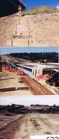
Photographs, Gary Partington, Greensborough By-Pass, 1986_
... metropolitan ring road... by the eastern end of the Metropolitan Ring Road..... It is intersected by the eastern end of the Metropolitan Ring Road ...The Greensborough by-pass extends from Grimshaw Street in the south to Diamond Creek Road in the north. It is intersected by the eastern end of the Metropolitan Ring Road.Unpublished photographs of the construction of the Greensborough by-pass.21 colour photographs of the construction phase of the Greensborough By-pass.greensborough bypass, roads, greensborough, gary partington, metropolitan ring road -
 Whitehorse Historical Society Inc.
Magazine - Periodical, North East Link Project, 1/03/2017 12:00:00 AM
... Which will link the Metropolitan Ring Road at Greensborough... will link the Metropolitan Ring Road at Greensborough to East Link... the Metropolitan Ring Road at Greensborough to East Link Freeway. Which ...The first issue of the North East Link Project. Which will link the Metropolitan Ring Road at Greensborough to East Link Freeway.The first issue of the North East Link Project which will link the Metropolitan Ring Road at Greensborough to East Link Freeway.The first issue of the North East Link Project. Which will link the Metropolitan Ring Road at Greensborough to East Link Freeway.north east link project, freeways, eastlink -
 Greensborough Historical Society
Article, Royal Automobile Club of Victoria et al, Ring of ire, 2016_02
... metropolitan ring road... the Metropolitan Ring Road at Greensborough and the Eastlink at either... streets in the Banyule area. eastlink metropolitan ring road ...Discussion of the need to provide a link between the Metropolitan Ring Road at Greensborough and the Eastlink at either Bulleen or Ringwood, to alleviate traffic congestion on Rosanna Road and other streets in the Banyule area.Four pages, text and coloured photographsRoyal Auto Feb. 2016 p. 15-19eastlink, metropolitan ring road, rosanna road rosanna -
 Greensborough Historical Society
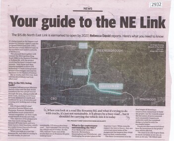
Article - Newspaper Clipping, Your guide to the NE Link, 26/02/2020
... metropolitan ring road... Ring Road to the Eastern Freeway at Bulleen Road. This Feb 2020... the Metropolitan Ring Road to the Eastern Freeway at Bulleen Road. This Feb ...The North East link Project, is touted as the biggest road project in Victoria's history and will connect the Metropolitan Ring Road to the Eastern Freeway at Bulleen Road. This Feb 2020 article outlines the reasons for the project.News clipping, black and white text and colour image.north east link, , rosanna road rosanna, metropolitan ring road -
 Greensborough Historical Society
Newspaper Clipping, Diamond Valley Leader, Taking on gridlock, 10/05/2017
... metropolitan ring road... end of the Western (Metropolitan) Ring Road.... (Metropolitan) Ring Road. transport metropolitan ring road Diamond ...Millions were splashed on roads and transport during the 2017-2018 State Budget in a bid to ease the gridlock which plagues the region. Including improvements to the Greensborough end of the Western (Metropolitan) Ring Road.News article 1 page, black text, colour image.transport, metropolitan ring road -
 Greensborough Historical Society
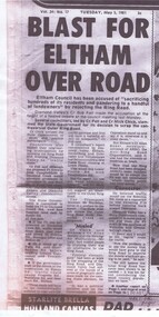
Newspaper - Newspaper Clipping (copy), Blast for Eltham over road, 05/05/1981
... metropolitan ring road... to the present day metropolitan ring road.... to the present day metropolitan ring road. metropolitan ring road shire ...An early report of the dissention between Eltham and Diamond Valley shires over the proposed "outer ring road" and its possible extension through to Eltham. This was a precursor to the present day metropolitan ring road.News clipping, black text, slightly smudged copy..metropolitan ring road, shire of diamond valley, shire of eltham -
 Greensborough Historical Society
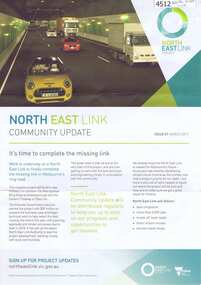
Leaflet, North East Link Authority, North East Link community update: issue 01 March 2017, 2017
... metropolitan ring road... of Metropolitan Ring Road... Link Tunnels, completion of Metropolitan Ring Road north east ...The North East Link Authority was set up to lead development of this project. The commencement of technical work has been approved by the State Government of Victoria. This newsletter, and additional leaflets, are to keep the community informed of project designs, developments and opportunities for consultation. Includes North East Link Tunnels, completion of Metropolitan Ring Road4 page leaflets, colour text and images; with further information leaflets on specific topics related to the projectnorth east link, metropolitan ring road, north east link tunnels -
 Greensborough Historical Society
Newspaper Clipping, Diamond Valley Leader et al, Options brought to table, 18/01/2017
... metropolitan ring road... link banyule metropolitan ring road Diamond Valley Leader Tom ...A radical plan, which would see the North East Link built with fly-overs and trenches rather than tunnels, could affect Banyule residents.News article 1 page, black text.north east link, banyule, metropolitan ring road -
 Greensborough Historical Society
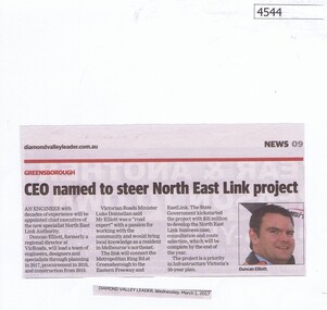
Newspaper Clipping, Diamond Valley Leader, CEO named to steer North East Link project, 01/03/2017
... metropolitan ring road... Authority. north east link metropolitan ring road duncan elliott ...An engineer with decades of experience will be appointed chief executive of the new specialist North East Link Authority.News article 1 page, black text, colour image.north east link, metropolitan ring road, duncan elliott -
 Greensborough Historical Society
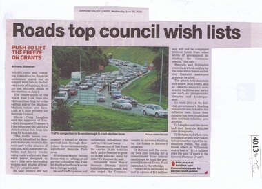
Newspaper Clipping, Diamond Valley Leader, Roads top council wish lists, 29/06/2016
... metropolitan ring road.... traffic north east link banyule council metropolitan ring road ...Traffic issues in Banyule and surrounding areas are discussed.News clipping, black text and colour imagetraffic, north east link, banyule council, metropolitan ring road, banyule city council -
 Eltham District Historical Society Inc
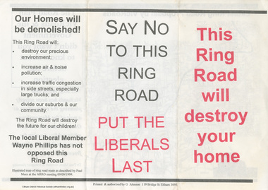
Document - Flyer, Greg Johnson et al, Say No to this Ring Road, 9 Sep 1999
... Metropolitan Ring Road... Metropolitan Ring Road Vicroads Victoria Wayne Phillips M.P. Map Greg ...anti ring road organisation (arro), dr paul mees, greg johnson, kennett government, liberal government, melbourne, metropolitan orbital transport corridor, metropolitan ring road, vicroads, victoria, wayne phillips m.p., map -
 Greensborough Historical Society
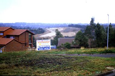
Slide - Photograph, John Ramsdale, Construction of the Western Ring Road: Slide 57, 1990s
... metropolitan ring road... visual material. western ring road metropolitan ring road apollo ...Photograph shows residential development with auction board and construction of the Western Ring Road in background.Part of the John Ramsdale collection of slides and audio visual material.Colour photograph scanned from slide.No maker's marks. No caption on slide.western ring road, metropolitan ring road, apollo parkways -
 Greensborough Historical Society
Map, Melbourne and Metropolitan Board of Works. Survey Division, MMBW, Yarra 2500 / 11.22. Bundoora, 1979_01
... ) and "proposed future freeway" (now Metropolitan Ring Road)... Metropolitan Ring Road) mmbw melbourne and metropolitan board of works ...Melbourne and Metropolitan Board of Works. Yarra 2500 [base map] 11-22. Bundoora. Parish of Keelbundoora 2856, Municipalities of Diamond Valley 257 and Whittlesea 239. Prominent streets include: Greenhills Road, Cabernet Crescent and Plenty Road. Includes Parade College (Christian Brothers) and "proposed future freeway" (now Metropolitan Ring Road)MMBW Map in 1:2500 [scale] series. Cream parchment with green tape reinforcing on edges and punched holes on left edge.mmbw, melbourne and metropolitan board of works, shire of diamond valley, bundoora - maps -
 Greensborough Historical Society
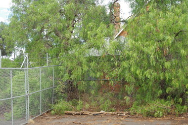
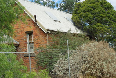
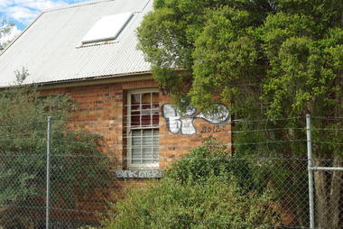
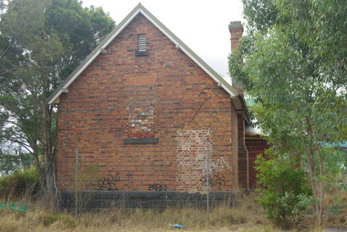
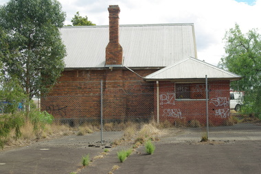
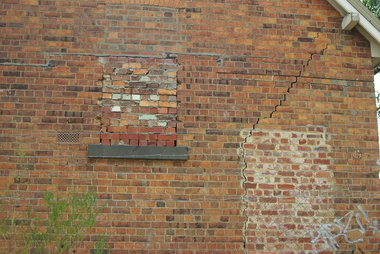
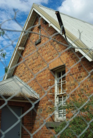
Photograph - Digital Image, Bundoora Primary School Bu1915 (old building) 1, 18/03/2014
... Road and the Metropolitan Ring Road. The School has a Victorian... Road and the Metropolitan Ring Road. The School has a Victorian ...Bundoora Primary School No.1915 was constructed in 1877 of brick on a bluestone base with an iron roof and small porch. The school consisted of a single room with the dimensions 30 feet by 18 feet. It was a small rural school and in use for over 100 years. Today it sits abandoned at the intersection of Plenty Road and the Metropolitan Ring Road. The School has a Victorian Heritage Overlay (no H062) Photograph by Marilyn Smith 2014. Update: The old building has been incorporated into a childcare facility.Digital copy of colour photograph. bundoora primary school, bundoora state school -
 Greensborough Historical Society
Photograph - Digital Image, Bundoora Primary School Bu1915 (old building) 2, 18/03/2014
... Road and the Metropolitan Ring Road. The School has a Victorian... Road and the Metropolitan Ring Road. The School has a Victorian ...Bundoora Primary School No.1915 was constructed in 1877 of brick on a bluestone base with an iron roof and small porch. The school consisted of a single room with the dimensions 30 feet by 18 feet. It was a small rural school and in use for over 100 years. Today it sits abandoned at the intersection of Plenty Road and the Metropolitan Ring Road. The School has a Victorian Heritage Overlay (no H062) Photograph by Marilyn Smith 2014. Update: The old building has been incorporated into a childcare facility.Digital copy of colour photograph. bundoora primary school, bundoora state school -
 Greensborough Historical Society
Photograph - Digital Image, Bundoora Primary School Bu1915 (old building) 3, 18/03/2014
... Road and the Metropolitan Ring Road. The School has a Victorian... Road and the Metropolitan Ring Road. The School has a Victorian ...Bundoora Primary School No.1915 was constructed in 1877 of brick on a bluestone base with an iron roof and small porch. The school consisted of a single room with the dimensions 30 feet by 18 feet. It was a small rural school and in use for over 100 years. Today it sits abandoned at the intersection of Plenty Road and the Metropolitan Ring Road. The School has a Victorian Heritage Overlay (no H062) Photograph by Marilyn Smith 2014. Update: The old building has been incorporated into a childcare facility.Digital copy of colour photograph. bundoora primary school, bundoora state school -
 Greensborough Historical Society
Photograph - Digital Image, Bundoora Primary School Bu1915 (old building) 4, 18/03/2014
... Road and the Metropolitan Ring Road. The School has a Victorian... Road and the Metropolitan Ring Road. The School has a Victorian ...Bundoora Primary School No.1915 was constructed in 1877 of brick on a bluestone base with an iron roof and small porch. The school consisted of a single room with the dimensions 30 feet by 18 feet. It was a small rural school and in use for over 100 years. Today it sits abandoned at the intersection of Plenty Road and the Metropolitan Ring Road. The School has a Victorian Heritage Overlay (no H062) Photograph by Marilyn Smith 2014. Update: The old building has been incorporated into a childcare facility.Digital copy of colour photograph. bundoora primary school, bundoora state school -
 Greensborough Historical Society
Photograph - Digital Image, Bundoora Primary School Bu1915 (old building) 5, 18/03/2014
... Road and the Metropolitan Ring Road. The School has a Victorian... Road and the Metropolitan Ring Road. The School has a Victorian ...Bundoora Primary School No.1915 was constructed in 1877 of brick on a bluestone base with an iron roof and small porch. The school consisted of a single room with the dimensions 30 feet by 18 feet. It was a small rural school and in use for over 100 years. Today it sits abandoned at the intersection of Plenty Road and the Metropolitan Ring Road. The School has a Victorian Heritage Overlay (no H062) Photograph by Marilyn Smith 2014. Update: The old building has been incorporated into a childcare facility.Digital copy of colour photograph. bundoora primary school, bundoora state school -
 Greensborough Historical Society
Photograph - Digital Image, Bundoora Primary School Bu1915 (old building) 6, 18/03/2014
... Road and the Metropolitan Ring Road. The School has a Victorian... Road and the Metropolitan Ring Road. The School has a Victorian ...Bundoora Primary School No.1915 was constructed in 1877 of brick on a bluestone base with an iron roof and small porch. The school consisted of a single room with the dimensions 30 feet by 18 feet. It was a small rural school and in use for over 100 years. Today it sits abandoned at the intersection of Plenty Road and the Metropolitan Ring Road. The School has a Victorian Heritage Overlay (no H062) Photograph by Marilyn Smith 2014. Update: The old building has been incorporated into a childcare facility.Digital copy of colour photograph. bundoora primary school, bundoora state school -
 Greensborough Historical Society
Photograph - Digital Image, Bundoora Primary School Bu1915 (old building) 7, 18/03/2014
... Road and the Metropolitan Ring Road. The School has a Victorian... Road and the Metropolitan Ring Road. The School has a Victorian ...Bundoora Primary School No.1915 was constructed in 1877 of brick on a bluestone base with an iron roof and small porch. The school consisted of a single room with the dimensions 30 feet by 18 feet. It was a small rural school and in use for over 100 years. Today it sits abandoned at the intersection of Plenty Road and the Metropolitan Ring Road. The School has a Victorian Heritage Overlay (no H062) Photograph by Marilyn Smith 2014. Update: The old building has been incorporated into a childcare facility.Digital copy of colour photograph. bundoora primary school, bundoora state school -
 Greensborough Historical Society
Map, Melbourne and Metropolitan Board of Works. Survey Division, MMBW, Yarra 2500 / 12.22. Watsonia North, 1978_03
... Metropolitan Ring Road).... Metropolitan Ring Road). mmbw melbourne and metropolitan board of works ...Melbourne and Metropolitan Board of Works. Yarra 2500 [base map]. 12-22, Parishes of Keelbundora 2856, Municipalities of Whittlesea 239 and Diamond Valley 257. Shows street names, easement sizes, lot numbers, lodged plan numbers, names of prominent features, contour values, creek or river names. Watsonia Railway Station and environs. Prominent streets: Edmund Rice Parade and Macorna Street. Includes Christian Brothers Edmund Rice College and Janefield Special School sites and "proposed future freeway" (now Metropolitan Ring Road).MMBW Map in 1:2500 [scale] series. Cream parchment with green tape reinforcing on edges and punched holes on left edge.mmbw, melbourne and metropolitan board of works, shire of diamond valley, watsonia - maps, bundoora - maps -
 Eltham District Historical Society Inc
Document - Certificate of Title, Landata, Vol. 4930 Fol. 985900, Crown Portion 15 Section 5, Parish of Nillumbik, County of Evelyn, 1925
... ring road link between Diamond Creek and Ringwood. The chosen... ring road link between Diamond Creek and Ringwood. The chosen ...(Cancelled) Certificate of Title originally issued for Crown Portion 15, Section 5 to Robert David Taylor, of Eltham, County of Evelyn, Farmer, 13 March 1925. It is with this title that the land allotment was subdivided into 48 lots. The title shows the issuance to Robert David Taylor with encumbrance placed upon it by immediate former owner, Hugh Patrick Keogh, a former member for Gippsland and Melbourne Real Estate Agent. Following Taylor's death in 1934 the title passes to his Executors, sons Robert David Taylor of Bible Street, Eltham and William McLelland Vance Taylor of Northcote. The property is then sold to Frank Stokes who develops the Stokes Orchard. Compulsory acquisitions by the Melbourne Metropolitan Board of Works and State Electricity Commission show provisions of easemenst for town water supply and high voltage power transmission lines. Subsequent lots are then sold off with the development of the Stokes Orchard Estate residential development in the mid to late 1970s. A History of the Development of Crown Allotment 15, Section 5, Parish of Nillumbik – Stokes Orchard Crown Allotment 15, Section 5, Parish of Nillumbik (CA15) is a square allotment of 158 acres or approximately a quarter of a square mile. It lies just beyond the eastern end of Pitt Street, south of Nyora Road to the northern end of Eucalyptus Road and extends east from Eucalyptus Road to Reynolds Road. The topography of CA15 is generally steep, sloping up to a hill near the centre of the land, the ridgeline passing through the properties along the southern side of Diosma Road. Eucalyptus Road is a straight north-south road with its northern end at the north west corner of CA15. Until the end of the 1970s this road was an un-named Government Road and was largely not open to traffic. With residential development in the 1970s the road was constructed, and the council allocated the name obviously in recognition of the predominant species of the local bushland. CA15 was purchased from the Crown by George D’Arley Boursiquot, a prominent Melbourne printer, on 28th October 1852. On November 23, 1922, former Member for Gippsland and Melbourne Real Estate Agent, Hubert Patrick Keogh purchased the allotment then sold it March 13, 1925, to local farmer, Robert David Taylor, a former Shire of Eltham Councillor (1911-1920) and Shire President (1919). Taylor had extensive land holdings stretching west towards Bible Street and Main Road. The Taylor home was situated at the top of the hill in Bible Street at present day 82 Bible Street. At the time of Taylor’s purchase in 1925, CA15 was subdivided into 48 lots that could be described as small rural properties or large residential lots. A typical lot size was one hectare or 2.5 acres. The subdivision created two roads, Nyora Road, and Diosma Road, each following an irregular alignment between Eucalyptus and Reynolds Roads. However, the lots were not sold off separately nor were the roads constructed. The land effectively remained as one parcel for many further years. Robert David Taylor died November 30, 1934, and probate was granted to his son of the same name, Robert David Taylor of Bible Street, Salesman and William McLelland Vance Taylor of 73 Emmeline Street, Northcote, Clerk, with the transfer of the land into their names on July 8, 1935. Frank Stokes worked as a qualified accountant at Kennons leather factory in Burnley, while living at 1 Thomas Street, Mitcham. He suffered from migraines and wanted to return to working the land (he had previously worked on farms and orchards since coming to Australia from England in 1926, both in WA and Vic.). He first travelled to the district by train in July 1942 to find land with the intention to establish an orchard. By chance he met Arthur Bird of Bird Orchard (bounded by Pitt Street, Eucalyptus Road, and Wattle Grove) and they got talking over their common interest. Arthur put Frank up for the night and pointed out the land, 158 acres- part of the Taylor Estate- £900, Crown Allotment 15, Section 5, Parish of Nillumbik (CA15) somewhat diagonally opposite Bird Orchard. Stokes applied through the Riverina Agency to purchase the land who in turn applied for permission from Canberra to sell as there was a new government regulation introduced during the Second World War banning land sales except for immediate production. Stokes obtained a loan on his Mitcham house of £600 @ 5% and paid £450 deposit with quarterly payments of £15 spread over 5 years. Stokes was assisted and advised by Arthur Bird who farmed the neighbouring orchard. In early 1943 Stokes took possession and would catch the train out to Eltham on Fridays after work and began building a hut on the corner of Nyora Road and the Government Road (Eucalyptus Road) for shelter and to lock up tools. He established an orchard on the central western part of the land through the centre of which ran a natural waterway (part of the present-day linear park) and was able to pay a neighbour (Hawkins) to help with clearing and fencing 25 acres, and with a horse and single furrowed plough, planted approximately 2,500 fruit trees - cherries, peaches, plums, almonds, pears, apricots and lemons as well as a few apples and oranges; a massive task. Aerial photographs from the 1940s through to the 1990s clearly show the orchard with most of the larger CA15 site remaining as natural bushland. A huge problem was hares and rabbits eating all the new buds off the tiny trees. As well as laying poison he painted the trees with a mixture of cow manure and lime, often working by moonlight. Procurement of wire and wire netting was difficult because of the war but after much effort he obtained a permit from the Agricultural Department for supplies in March 1944. In February 1945 Stokes applied for a permit to build a “packing shed” as no house building was allowed. It was to be 33 feet x 21 feet and cost £312. It was constructed mostly from second-hand materials, which were hard to obtain, especially iron for roofing. Stokes finished work at Kennons on October 31, 1945, and in March 1946 he sold the family home at Mitcham for £1,230 plus £170 for furniture. On May 15, 1946, title to the CA15 property was issued to Frank Howard Alfred Stokes, Orchardist and Gladys Ethel Stokes, Married Woman, both of Pitt Street, Eltham. The family of five then moved into the very unfinished “packing shed” at Eltham, which was a struggle to weatherproof. Eventually rooms were divided off and lined with hessian bags and whitewashed. Their income was firewood (cut and sold), selling rockery stones and cut Sweet Bursaria. (It was discovered during the 1940s that Sweet Bursaria contained the sunscreen compound Aesculin. The RAAF utilised this compound from Sweet Bursaria during WW2 for pilots and gunners.) The orchard’s first fruit sale was a half-case of Le Vanq peaches in December 1947 for the price of 8 shillings. In 1956 plans for house were drawn and Glen Iris bricks purchased (1956 Olympic Rings variant). The building of the house commenced in 1957 - 12 feet of original packing shed was removed – and was completed in 1959. Water was connected from newly built pressure storage on the property at the end of 1959 and the electricity connection for the first time at 3pm on April 29, 1960. The house remains to present day (somewhat modified) at 1 Nyora Road, home to Nyora Studio Gallery. On occasions, spare remnants of the 1956 bricks have been known to be unearthed in gardens on the estate as they were utilised by Frank Stokes to fill in rabbit holes. On May 26, 1950, a parcel of land was compulsorily acquired by the Melbourne and Metropolitan Board of Works on the hilltop to establish an easement for a high-level service reservoir to augment Eltham’s water supply. The project also included pipe tracks for the necessary water mains. The reservoir has now been superseded by higher level water tanks east of Reynolds Road and its former site is now a public reserve. On November 27, 1964, the State Electricity Commission served notice to compulsorily acquire a further parcel through the eastern part of the land for a major electricity transmission line that augmented supply from the La Trobe Valley to Melbourne. The easement was registered February 11, 1966. The easement was widened July 18, 1969 for a second transmission line to be constructed. In 1971 Melbourne Metropolitan Planning Scheme amendments adopted Nyora Road as the boundary between a residential zone to the north and a rural zone to the south. This determined the future development of the land. In the mid-1970s the Shire of Eltham divided the orchard into numerous rate-able parcel lots, the 48 lots having been established in 1925 and the subsequent rates assessment proved unsustainable for Stokes. He commenced selling lots outside the boundary of the orchard, north of Diosma and South of Nyora. However shortly later the land between Nyora and Diosma Roads and west of the electricity easement was sold and subdivided into residential lots, a housing development by Macquarie Builders and marketed as the Stokes Orchard Estate. New streets were created, and most were named after trees, although one, Stokes Place, commemorates the former owners. The development was undertaken in two stages; Stage 1 (1975) encompassing Scarlet Ash Court, Ironbark Close and Peppermint Grove bounded by Nyora and Eucalyptus roads and Stage 2 (1978) encompassing Stokes Place, Orchard Way, The Crest and The Lookout bound by Nyora and Diosma roads. The developer, Macquarie Builders went bankrupt shortly after the release of Stage 2 leaving many purchasers to fend for themselves and arrange for their own independent builders. There were also difficulties with sewerage for the land immediately south of Diosma Road and so the conventional residential lots were abandoned in favour of larger lots. The development of Orchard Way, The Crest and The Lookout did not proceed as planned and the proposed lots were incorporated into five-acre parcels instead. These included a low-density group housing development by the Graves family and the award winning Choong House (1983) with Gordon Ford developed garden immediately next door situated on the ridge of the hill nestled amongst the original bush, Eucalypt trees and Sweet Bursaria. In 1994, Nillumbik Shire Council applied Significant Environment and Significant Landscape overlays upon the properties on the south side of Diosma Road to ensure protection of this natural bush garden environment. With the arrival of the sewer along Diosma Road in the 1990s, most of these five-acre parcels have since been subdivided multiple times. The Choong house presently sits on a 2.7-acre property, which in 2022 Nillumbik Council nominated for Cultural Significance Heritage protection and is considered potentially significant at State level. The Stokes family were also associated with the Eltham Christian Church. In the 1970s this church had met in temporary premises in Eltham. Lots of the original 1925 subdivision remained south of Nyora Road and a number of these lots were utilized for the Eltham Christian School, which was established by the Eltham Christian Church in 1981. The school operated on this site until 2000. The premises are now used by The Vine Baptist Church. By the mid-1980s the whole of CA15 had been developed for residential and school purposes, except for the sections north of Diosma Road and between the transmission lines and Reynolds Road. Sewerage issues had been resolved for the section north of Diosma Road and in 1987 it was in the process of being subdivided into residential lots. The development coincided with the discovery of colonies of the rare and endangered Eltham Copper Butterfly on the site. This resulted in a community and political campaign to save the butterfly habitat. With the co-operation of the land developer the subdivision was altered to create two bushland reserves in the critical butterfly habitat areas. In the late 1980s the State Government was investigating options for establishing a metropolitan ring road link between Diamond Creek and Ringwood. The chosen route was adjacent to Reynolds Road and so this created a freeze on development of CA15 between Reynolds Road and the electricity easement. The ring road proposal was eventually abandoned, and this part of the land was subdivided into low density residential lots. Diosma Road has been discontinued at the electricity easement and the eastern part incorporated into View Mount Court with access from Reynolds Road. The whole of CA15 has now been developed for residential or associated purposes, ranging from conventional density to quite low density south of Nyora Road. Some remnants of the orchard remain, a few cherry trees on the Graves property and a lone apple tree in Stokes Place. The butterfly reserves comprise significant areas of remnant bushland. Linear reserves through the estate link with central Eltham via the Woodridge linear reserve and with Research along the electricity easement. CA15 as it exists today has a complicated history of rural use, Government acquisition, urban development, and community action. References: • “Stokes Orchard, an incomplete history”; Russell Yeoman with Doug Orford • Correspondence, Beryl Bradbury (nee Stokes) • Aerial Photographs, 1931-1991, Landata (landata.vic.gov.au) • Certificate of Title, Vol. 4930 Fol. 985900 • Plan Number LP 10859 neil webster collection, diosma road, eltham copper butterfly, eucalyptus road, ironbark close, nyora road, peppermint grove, power transmission lines, reynolds road, scarlet ash court, stokes orchard estate, stokes place, woodridge estate, frank stokes, certificate of title -
 Eltham District Historical Society Inc
Photograph - Aerial Photograph, Landata, Eltham; Crown Allotment 15, Section 5, Parish of Nillumbik (Stokes Orchard Estate), Feb. 1956
... ring road link between Diamond Creek and Ringwood. The chosen... ring road link between Diamond Creek and Ringwood. The chosen ...Centred on present day Diosma Rd, Stokes Pl, Nyora Rd and Eucalyptus Rd Historic Aerial Imagery Source: Landata.vic.gov.au Aerial Photo Details: Project No :250 Project : MELBOURNE OUTER SUBURBS PROJECT Run : 18 Frame : 94 Date : 02/1956 Film Type : B/W Camera : EAG9 Flying Height : 10000 Scale : 12000 Film Number : 1176 GDA2020 : 37°42'30"S, 145°09'44"E MGA2020 : 338008, 5824963 (55) Melways : 22 C3 (ed. 42) A History of the Development of Crown Allotment 15, Section 5, Parish of Nillumbik – Stokes Orchard Crown Allotment 15, Section 5, Parish of Nillumbik (CA15) is a square allotment of 158 acres or approximately a quarter of a square mile. It lies just beyond the eastern end of Pitt Street, south of Nyora Road to the northern end of Eucalyptus Road and extends east from Eucalyptus Road to Reynolds Road. The topography of CA15 is generally steep, sloping up to a hill near the centre of the land, the ridgeline passing through the properties along the southern side of Diosma Road. Eucalyptus Road is a straight north-south road with its northern end at the north west corner of CA15. Until the end of the 1970s this road was an un-named Government Road and was largely not open to traffic. With residential development in the 1970s the road was constructed, and the council allocated the name obviously in recognition of the predominant species of the local bushland. CA15 was purchased from the Crown by George D’Arley Boursiquot, a prominent Melbourne printer, on 28th October 1852. On November 23, 1922, former Member for Gippsland and Melbourne Real Estate Agent, Hubert Patrick Keogh purchased the allotment then sold it March 13, 1925, to local farmer, Robert David Taylor, a former Shire of Eltham Councillor (1911-1920) and Shire President (1919). Taylor had extensive land holdings stretching west towards Bible Street and Main Road. The Taylor home was situated at the top of the hill in Bible Street at present day 82 Bible Street. At the time of Taylor’s purchase in 1925, CA15 was subdivided into 48 lots that could be described as small rural properties or large residential lots. A typical lot size was one hectare or 2.5 acres. The subdivision created two roads, Nyora Road, and Diosma Road, each following an irregular alignment between Eucalyptus and Reynolds Roads. However, the lots were not sold off separately nor were the roads constructed. The land effectively remained as one parcel for many further years. Robert David Taylor died November 30, 1934, and probate was granted to his son of the same name, Robert David Taylor of Bible Street, Salesman and William McLelland Vance Taylor of 73 Emmeline Street, Northcote, Clerk, with the transfer of the land into their names on July 8, 1935. Frank Stokes worked as a qualified accountant at Kennons leather factory in Burnley, while living at 1 Thomas Street, Mitcham. He suffered from migraines and wanted to return to working the land (he had previously worked on farms and orchards since coming to Australia from England in 1926, both in WA and Vic.). He first travelled to the district by train in July 1942 to find land with the intention to establish an orchard. By chance he met Arthur Bird of Bird Orchard (bounded by Pitt Street, Eucalyptus Road, and Wattle Grove) and they got talking over their common interest. Arthur put Frank up for the night and pointed out the land, 158 acres- part of the Taylor Estate- £900, Crown Allotment 15, Section 5, Parish of Nillumbik (CA15) somewhat diagonally opposite Bird Orchard. Stokes applied through the Riverina Agency to purchase the land who in turn applied for permission from Canberra to sell as there was a new government regulation introduced during the Second World War banning land sales except for immediate production. Stokes obtained a loan on his Mitcham house of £600 @ 5% and paid £450 deposit with quarterly payments of £15 spread over 5 years. Stokes was assisted and advised by Arthur Bird who farmed the neighbouring orchard. In early 1943 Stokes took possession and would catch the train out to Eltham on Fridays after work and began building a hut on the corner of Nyora Road and the Government Road (Eucalyptus Road) for shelter and to lock up tools. He established an orchard on the central western part of the land through the centre of which ran a natural waterway (part of the present-day linear park) and was able to pay a neighbour (Hawkins) to help with clearing and fencing 25 acres, and with a horse and single furrowed plough, planted approximately 2,500 fruit trees - cherries, peaches, plums, almonds, pears, apricots and lemons as well as a few apples and oranges; a massive task. Aerial photographs from the 1940s through to the 1990s clearly show the orchard with most of the larger CA15 site remaining as natural bushland. A huge problem was hares and rabbits eating all the new buds off the tiny trees. As well as laying poison he painted the trees with a mixture of cow manure and lime, often working by moonlight. Procurement of wire and wire netting was difficult because of the war but after much effort he obtained a permit from the Agricultural Department for supplies in March 1944. In February 1945 Stokes applied for a permit to build a “packing shed” as no house building was allowed. It was to be 33 feet x 21 feet and cost £312. It was constructed mostly from second-hand materials, which were hard to obtain, especially iron for roofing. Stokes finished work at Kennons on October 31, 1945, and in March 1946 he sold the family home at Mitcham for £1,230 plus £170 for furniture. On May 15, 1946, title to the CA15 property was issued to Frank Howard Alfred Stokes, Orchardist and Gladys Ethel Stokes, Married Woman, both of Pitt Street, Eltham. The family of five then moved into the very unfinished “packing shed” at Eltham, which was a struggle to weatherproof. Eventually rooms were divided off and lined with hessian bags and whitewashed. Their income was firewood (cut and sold), selling rockery stones and cut Sweet Bursaria. (It was discovered during the 1940s that Sweet Bursaria contained the sunscreen compound Aesculin. The RAAF utilised this compound from Sweet Bursaria during WW2 for pilots and gunners.) The orchard’s first fruit sale was a half-case of Le Vanq peaches in December 1947 for the price of 8 shillings. In 1956 plans for house were drawn and Glen Iris bricks purchased (1956 Olympic Rings variant). The building of the house commenced in 1957 - 12 feet of original packing shed was removed – and was completed in 1959. Water was connected from newly built pressure storage on the property at the end of 1959 and the electricity connection for the first time at 3pm on April 29, 1960. The house remains to present day (somewhat modified) at 1 Nyora Road, home to Nyora Studio Gallery. On occasions, spare remnants of the 1956 bricks have been known to be unearthed in gardens on the estate as they were utilised by Frank Stokes to fill in rabbit holes. On May 26, 1950, a parcel of land was compulsorily acquired by the Melbourne and Metropolitan Board of Works on the hilltop to establish an easement for a high-level service reservoir to augment Eltham’s water supply. The project also included pipe tracks for the necessary water mains. The reservoir has now been superseded by higher level water tanks east of Reynolds Road and its former site is now a public reserve. On November 27, 1964, the State Electricity Commission served notice to compulsorily acquire a further parcel through the eastern part of the land for a major electricity transmission line that augmented supply from the La Trobe Valley to Melbourne. The easement was registered February 11, 1966. The easement was widened July 18, 1969 for a second transmission line to be constructed. In 1971 Melbourne Metropolitan Planning Scheme amendments adopted Nyora Road as the boundary between a residential zone to the north and a rural zone to the south. This determined the future development of the land. In the mid-1970s the Shire of Eltham divided the orchard into numerous rate-able parcel lots, the 48 lots having been established in 1925 and the subsequent rates assessment proved unsustainable for Stokes. He commenced selling lots outside the boundary of the orchard, north of Diosma and South of Nyora. However shortly later the land between Nyora and Diosma Roads and west of the electricity easement was sold and subdivided into residential lots, a housing development by Macquarie Builders and marketed as the Stokes Orchard Estate. New streets were created, and most were named after trees, although one, Stokes Place, commemorates the former owners. The development was undertaken in two stages; Stage 1 (1975) encompassing Scarlet Ash Court, Ironbark Close and Peppermint Grove bounded by Nyora and Eucalyptus roads and Stage 2 (1978) encompassing Stokes Place, Orchard Way, The Crest and The Lookout bound by Nyora and Diosma roads. The developer, Macquarie Builders went bankrupt shortly after the release of Stage 2 leaving many purchasers to fend for themselves and arrange for their own independent builders. There were also difficulties with sewerage for the land immediately south of Diosma Road and so the conventional residential lots were abandoned in favour of larger lots. The development of Orchard Way, The Crest and The Lookout did not proceed as planned and the proposed lots were incorporated into five-acre parcels instead. These included a low-density group housing development by the Graves family and the award winning Choong House (1983) with Gordon Ford developed garden immediately next door situated on the ridge of the hill nestled amongst the original bush, Eucalypt trees and Sweet Bursaria. In 1994, Nillumbik Shire Council applied Significant Environment and Significant Landscape overlays upon the properties on the south side of Diosma Road to ensure protection of this natural bush garden environment. With the arrival of the sewer along Diosma Road in the 1990s, most of these five-acre parcels have since been subdivided multiple times. The Choong house presently sits on a 2.7-acre property, which in 2022 Nillumbik Council nominated for Cultural Significance Heritage protection and is considered potentially significant at State level. The Stokes family were also associated with the Eltham Christian Church. In the 1970s this church had met in temporary premises in Eltham. Lots of the original 1925 subdivision remained south of Nyora Road and a number of these lots were utilized for the Eltham Christian School, which was established by the Eltham Christian Church in 1981. The school operated on this site until 2000. The premises are now used by The Vine Baptist Church. By the mid-1980s the whole of CA15 had been developed for residential and school purposes, except for the sections north of Diosma Road and between the transmission lines and Reynolds Road. Sewerage issues had been resolved for the section north of Diosma Road and in 1987 it was in the process of being subdivided into residential lots. The development coincided with the discovery of colonies of the rare and endangered Eltham Copper Butterfly on the site. This resulted in a community and political campaign to save the butterfly habitat. With the co-operation of the land developer the subdivision was altered to create two bushland reserves in the critical butterfly habitat areas. In the late 1980s the State Government was investigating options for establishing a metropolitan ring road link between Diamond Creek and Ringwood. The chosen route was adjacent to Reynolds Road and so this created a freeze on development of CA15 between Reynolds Road and the electricity easement. The ring road proposal was eventually abandoned, and this part of the land was subdivided into low density residential lots. Diosma Road has been discontinued at the electricity easement and the eastern part incorporated into View Mount Court with access from Reynolds Road. The whole of CA15 has now been developed for residential or associated purposes, ranging from conventional density to quite low density south of Nyora Road. Some remnants of the orchard remain, a few cherry trees on the Graves property and a lone apple tree in Stokes Place. The butterfly reserves comprise significant areas of remnant bushland. Linear reserves through the estate link with central Eltham via the Woodridge linear reserve and with Research along the electricity easement. CA15 as it exists today has a complicated history of rural use, Government acquisition, urban development, and community action. References: • “Stokes Orchard, an incomplete history”; Russell Yeoman with Doug Orford • Correspondence, Beryl Bradbury (nee Stokes) • Aerial Photographs, 1931-1991, Landata (landata.vic.gov.au) • Certificate of Title, Vol. 4930 Fol. 985900 • Plan Number LP 10859 aerial photo, diosma road, eltham copper butterfly, eucalyptus road, ironbark close, nyora road, peppermint grove, peter & elizabeth pidgeon collection, power transmission lines, reynolds road, scarlet ash court, stokes orchard estate, stokes place, woodridge estate, frank stokes